(via TheNewswire)
 | |||||||||
 |  |  | |||||||
Highlights
Headwater has defined multiple high-priority drill targets located directly on trend north of Hecla Mining Company’s (“Hecla”) past producing Midas high-grade mine complex;
The Company interprets the project to represent a fully preserved epithermal system with potential for high-grade mineralization at depth below broad areas of favourable alteration;
CSAMT geophysical surveys have identified several high-resistivity zones interpreted to represent silicification and possible feeder structures;
Radiometric survey results show both a broad radiometric low and linear radiometric highs interpreted to represent structurally controlled zones of alteration potentially associated with mineralized epithermal feeder structures;
An aeromagnetic survey has highlighted several linear magnetic lows interpreted as corridors of structurally controlled mag-destructive alteration which may also indicate feeder structures at depth; and,
A final drill plan is currently being developed for a multi-rig maiden drill program scheduled to commence in Q2.
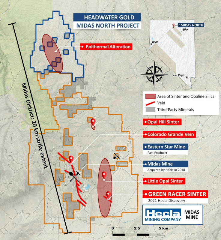
Click Image To View Full Size
Figure 1: Map of the Midas high-grade vein district in northern
Midas North Geophysical Surveys:
The results of the geophysical surveys confirm the utility of using magnetics, radiometrics, gravity and CSAMT resistivity, together with geology, to generate high-quality drill targets at Midas North below the broad area of favourable epithermal alteration outcropping at surface.
The 2022 geophysical programs consisted of:
A controlled-source audio-frequency magnetotelluric (“CSAMT”) resistivity survey totalling 36.3 line-kilometres (“line-km”) on eight parallel 400 metre (“m”) spaced profiles;
Helicopter airborne magnetic and radiometric surveys totalling 357 line-km completed at 100 m spacing totalling 32.5 km; and,
A ground gravity survey consisting of 767 stations on a 200 m grid to 400 m grid regionally, with a total survey footprint of 114 km
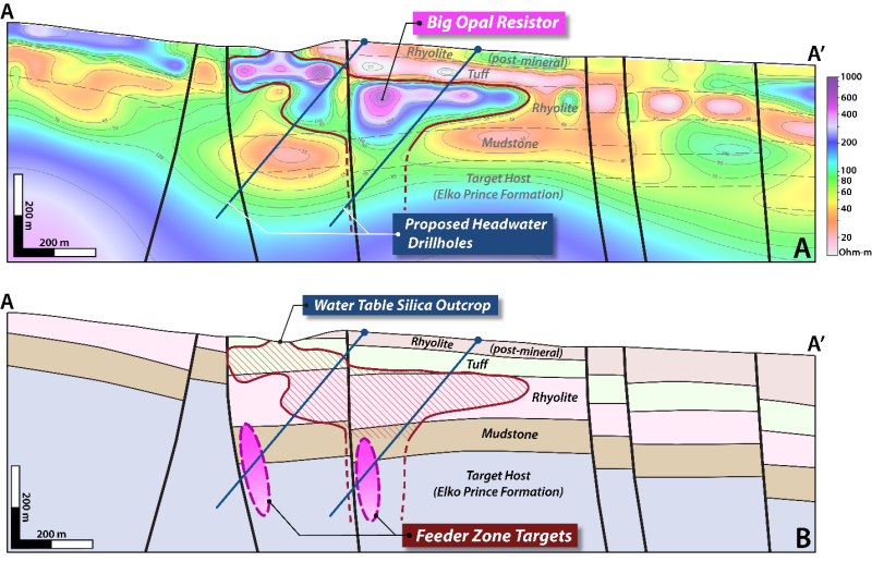
Click Image To View Full Size
Figure 2: (A) CSAMT geophysics apparent resistivity profile with (B) Headwater’s working geological model and preliminary drill targets in the Big Opal target area. See Figure 3 for plan map indicating the CSAMT line position and geological cross section location.
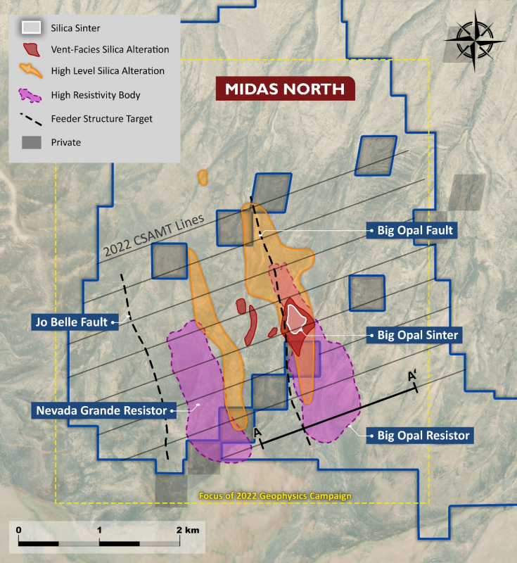
Click Image To View Full Size
Figure 3: Midas North property map highlighting the principal alteration zones, target areas and approximate geophysical survey footprints shown in detail in Figures 5, 6 and 7.
Geophysical Targets Areas:
Headwater has identified multiple drill targets by analyzing the multi-parameter geophysical data described above. The principal targets contain geophysical and geological characteristics indicating potential to host kilometre-scale feeder zones at depths of 200m to 400m below the outcropping mapped sinters and other high-level hot-spring-type alteration mapped at surface.
The principal targets are interpreted as follows:
Big
Opal Sinter Target NNW-striking sub-vertical resistivity break beneath outcropping vent facies sinter deposits with interpreted mafic sill at depth. Strong geologicalsimilarities to Hecla’s recent Green Racer Sinter vein discovery on the adjacentMidas Mine complex.Big Opal Fault Target Kilometre-scale NNW-striking resistivity break at the margin of a large resistivity high (Big Opal Resistor) interpreted as a thick water table silica blanket.
Big Opal Resistor Target: High-angle resistivity break beneath the Big Opal Resistor.
Jo Belle Fault Target District-scale fault associated with kilometre-scale, strongly resistive CSAMT feature (Nevada Grande Resistor). The stratigraphic offset and fault orientation are considered geologically comparable to the high-grade Colorado Grande vein in the main Midas district. Strong illite-adularia alteration is interpreted from a NNW-trending radiometric high (potassium channel) along the fault trace.
Nevada Grande Resistor Large resistor with approximately 2 kilometres of strike extent in the hanging wall of the Jo Belle fault interpreted to potentially represent a second locus of fluid flux and vein formation separate from the Big Opal structural corridor.
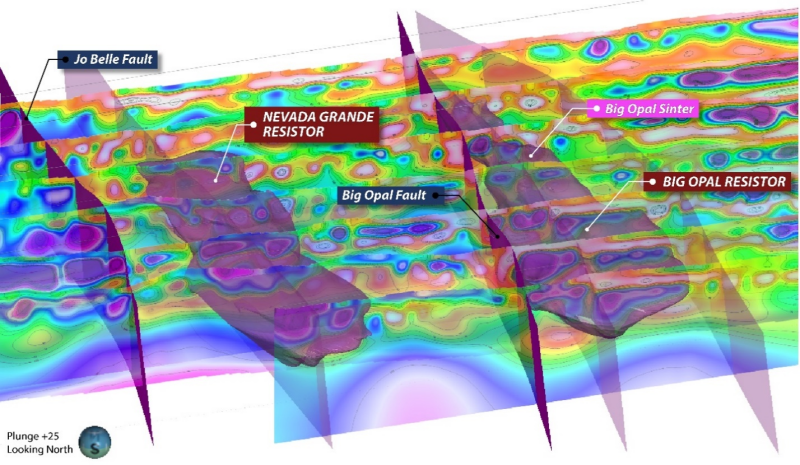
Click Image To View Full Size
Figure 4: 3D oblique view of CSAMT geophysical profiles, high-resistivity anomalies, interpreted faults and surface alteration features. The resistivity volumes shown are interpretedto represent extensive zones of pervasive silicification with potential for epithermal feeder zones at depth. CSAMT sections are on 400 m spaced lines. See Figure 2 for resistivity scale.
The CSAMT data collected by the Company has proven particularly effective for mapping the subsurface geometries of interpreted silica alteration beneath areas of high-level silica and steam-heated clay alteration, interpreted to represent the upper portion of a completely preserved epithermal system. Multiple high-angle resistivity breaks occur adjacent to and beneath shallow, tabular resistive bodies, each with over 2 kilometres of strike length (Figures 2, 3 and 4).
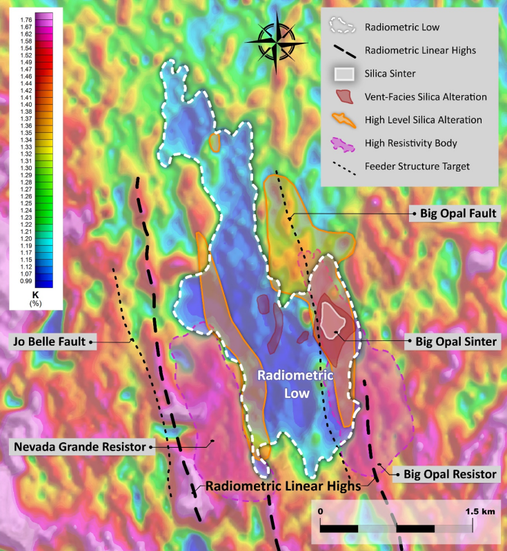
Radiometric survey results and potassium data in particular show discrete linear radiometric highs which may represent corridors of illite-adularia alteration that are subparallel to the feeder structures interpreted from the CSAMT data. The potassium data additionally reveal a broad, spatially continuous low coincident with the principal area of strong surface alteration (Figure 5) potentially attributable to a broad zone of argillic alteration.
Click Image To View Full Size
Figure 5: Radiometric survey potassium channel results showing central radiometric low, potentially attributable to extensive clay alteration and discrete linear radiometric highs which may represent structurally controlled zones of illite-adularia alteration.
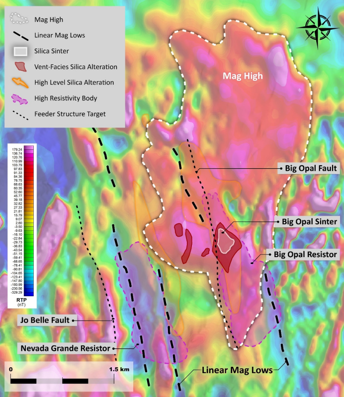
Strong contrasts in magnetic response reveal numerous NNW-trending linear magnetic lows, as well as a broad magnetic high in the Big Opal area (Figure 6). The linear magnetic low features are consistent withmagnetite-destructive alteration of the host volcanic rocks along structural corridors which potentially focused geothermal fluids. Several discrete magnetic highselsewhere on the property correspond with outcropping mafic sills. The large, low-amplitude magnetic high is interpreted by Headwater as a possible buried mafic intrusion, analogous in character to the sill-dike complexes spatially and temporally associated with high-grade vein deposits elsewhere in northern
Click Image To View Full Size
Figure 6: Aeromagnetic geophysical survey highlighting several linear zones of magnetite-destructive alteration interpreted to represent potential feeder structures. The strong magnetic signature beneath the Big
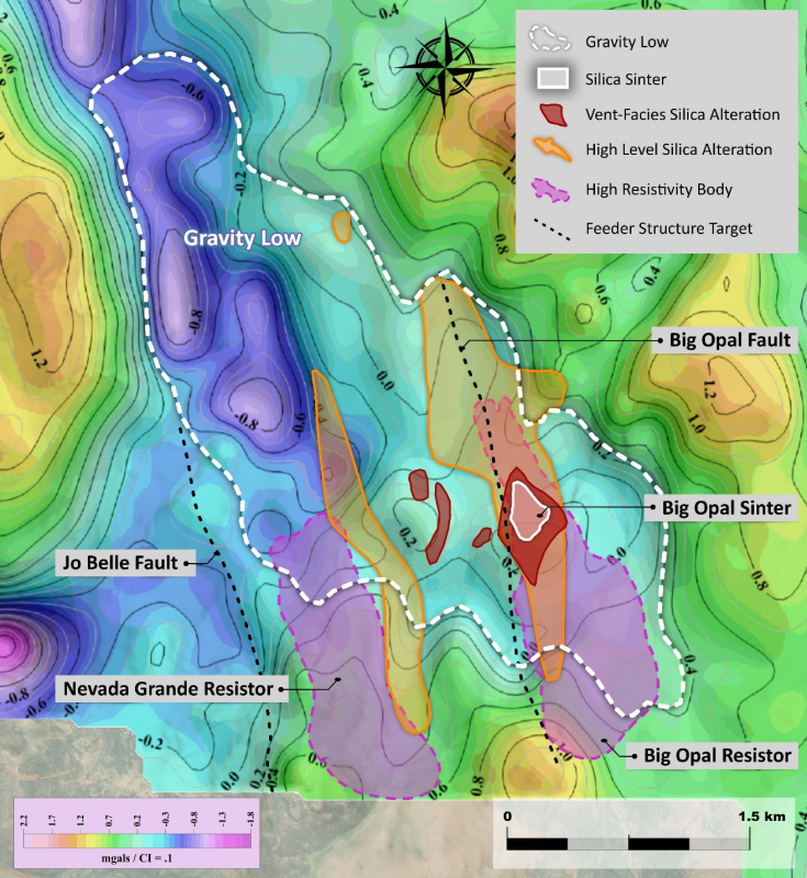
The core of the property is characterized by a broad gravity low which suggests a possible zone of pervasive argillic alteration in the surrounding volcanic host rock. The gravity low broadly overlaps with the footprint of a radiometric low and encompasses the areas of highest intensityalteration mapped at surface. The NNW elongation of the gravity low is consistent with property-wide structural trends detected by other geophysical surveys and surface mapping.
Click Image To View Full Size
Figure 7: Residual gravity image showing a broad embayment in the central project area interpreted to correspond to the footprint of intense clay alteration.
About the
Headwater’s 100% owned and royalty-free Midas North project in
Earn-in Agreement with
During the staged earn-in phase,
The Midas North project is one of four Headwater projects under earn-in agreements with
About
For more information, please visit the Company's website atwww.headwatergold.com.
On Behalf of the Board of Directors
President and CEO
+1 (775) 409-3197
cstroup@headwatergold.com
For further information, please contact:
Investor Relations Manager
+1 (778) 867-5016
bzerb@headwatergold.com
Qualified Person
The technical information contained in this news release has been reviewed and approved by
1 The Midas North project owned by the Company hosts exploration targets with no known resources or reserves. Gold mineralization onHecla’s adjacent
2 Goldstrand, P.M., and Schmidt, K.W., 2000, Geology, mineralization, and ore controls at the Ken Snyder gold-silver mine,
Forward-Looking Statements:
This news release includes certain forward-looking statements and forward-looking information (collectively, “forward-looking statements”) within the meaning of applicable Canadian securities legislation. All statements, other than statements of historical fact, included herein including, without limitation, statements regarding future capital expenditures, exploration activities and the specifications, targets, results, analyses, interpretations, benefits, costs and timing of them, Newcrest’s anticipated funding of the earn-in projects and the timing thereof, and the anticipated business plans and timing of future activities of the Company, are forward-looking statements. Although the Company believes that such statements are reasonable, it can give no assurance that such expectations will prove to be correct. Often, but not always, forward looking information can be identified by words such as “pro forma”, “plans”, “expects”, “may”, “should”, “budget”, “scheduled”, “estimates”, “forecasts”, “intends”, “anticipates”, “believes”, “potential” or variations of such words including negative variations thereof, and phrases that refer to certain actions, events or results that may, could, would, might or will occur or be taken or achieved. Forward-looking statements involve known and unknown risks, uncertainties and other factors which may cause the actual results, performance or achievements of the Company to differ materially from any future results, performance or achievements expressed or implied by the forward-looking statements. Such risks and other factors include, among others, risks related to the anticipated business plans and timing of future activities of the Company, including the Company’s exploration plans and the proposed expenditures for exploration work thereon, the ability of the Company to obtain sufficient financing to fund its business activities and plans, the risk that
Readers are cautioned not to place undue reliance on forward-looking statements. The Company undertakes no obligation to update any of the forward-looking statements, except as otherwise required by law.
Copyright (c) 2023 TheNewswire - All rights reserved.
Copyright (c) 2023 TheNewswire - All rights reserved., source


