Highlights:
- Geologically, the Project is bounded by two basins marking an unconformity that has garnered global attention for uranium exploration (please see Figure 2).
- The Nut
Lake Property has the potential to host unconformity vein and breccia type uranium bearing systems. - The most notable concentrations of this deposit type (better known as “Beaverlodge-Type” vein uranium deposits - please see Figure 2) is situated in the
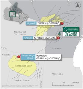
Athabasca basin in northernSaskatchewan and are pegged as being one of the most important sources of uranium inCanada producing ~62.8 M lbs of uranium at ~0.20% U3O8.5 - The Angilak Deposit (historically known as the Lac 50 Deposit and recently purchased by Atha Energy Corp.) and the Kiggavik Deposit are located ~55km to the south and ~135km to the north respectively of the Nut
Lake Property in theThelon Basin (please see Figure 1). - Exploration criteria of the
Athabasca Basin can be applied to theThelon Basin due to their similarities including:- Similar geologic age;
- Similar volcanic rocks and alteration products;
- Reactivated faulting;
- Multiple stages of uranium remobilization and deposition; and
- Basement-hosted alteration assemblages exhibiting gravity lows that serve as useful exploration vectors.
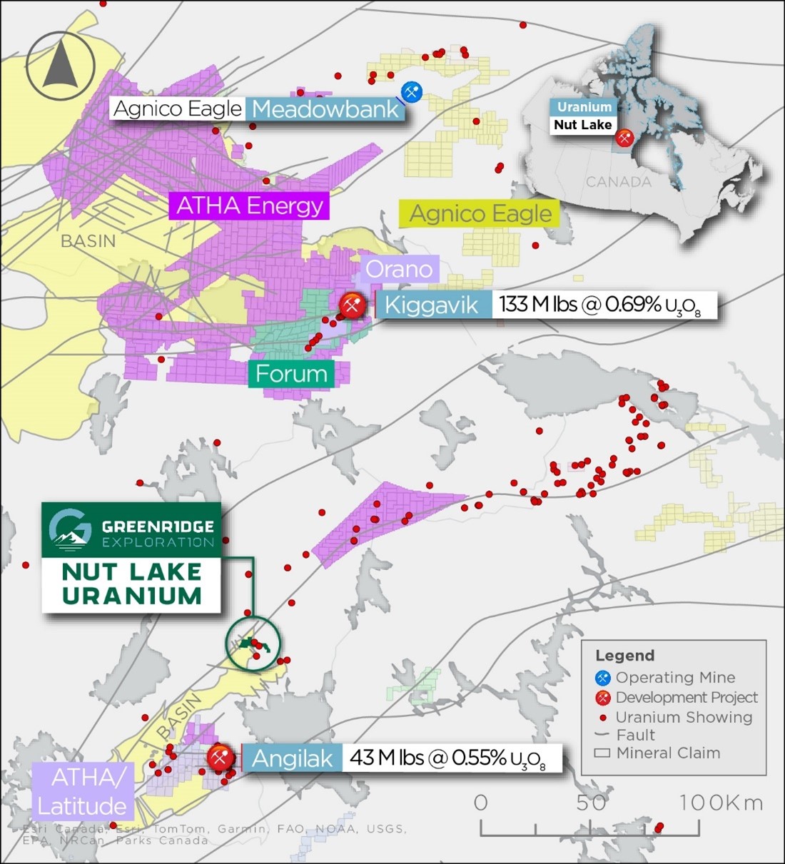
Figure 1 – Nut Lake Property Regional Map
Atha Energy Corp. & The Angilak Uranium Deposit (formally known as the Lac 50 Deposit)
The Project is located ~55KM north of the recently acquired Angilak Uranium Deposit with a historical resource of 43Mlbs of U3O8 @ 0.69% by Atha Energy Corp. and ~47km south of a major newly staked land position by Atha Energy Corp. This newly acquired land position was staked approximately one week prior to the acquisition of
Regarding its geological context, the
The following are key points about the
- Location:
The Beaverlodge Uranium District is situated in the northern part ofSaskatchewan , near the town ofUranium City . It lies within the Precambrian Shield, a geological formation rich in uranium deposits. - Discovery and Exploration: Uranium deposits in the
Beaverlodge area were discovered in the late 1940s, sparking a rush of exploration and development. The district quickly became one of the most important uranium-producing regions inCanada . - Geological Characteristics: The uranium deposits in the
Beaverlodge District are primarily hosted within metasedimentary rocks of theWollaston Group , which is part of the Precambrian Shield. These deposits are often associated with unconformities between different rock formations. - Mining Operations: Several mines operated within the
Beaverlodge Uranium District during its peak production years, including theBeaverlodge Mine , theLorado Mine , and theGunnar Mine . These mines produced significant quantities of uranium to supportCanada's nuclear energy program and the global demand for uranium during the Cold War era. - Legacy: While active mining operations in the
Beaverlodge Uranium District have largely ceased, the area remains significant historically and geologically. It serves as a reminder ofCanada's role in uranium production and its contribution to nuclear energy globally.
Overall, the
The Kiggavik Deposit
The Nut
The geology of the Kiggavik Deposits have been under study since the 1970s, with drilling and ore sampling activities since 2007 largely confirming previous interpretations regarding grade distribution and lithology.
Mineralization is generally finely disseminated along foliation planes or in veinlets parallel to the foliation, with occurrences in fracture infills and coatings along cross-cutting structures similar to what has been historically defined at the Nut
Exploration Criteria of the
Exploration criteria utilized in the
- Both basins' basement terranes feature widespread intrusive and extrusive magmatic events occurring at 2.60, 1.83, and 1.75 billion years ago, with similar volcanic rocks and alteration products, particularly in the latter two events.
- Complex sequences of arkosic lithic sandstone filled each basin post-1.7 billion years ago, originating from uranium-rich terranes and capped by stromatolitic dolostone.
- Pervasive diagenetic events have altered strata in both basins, resulting in quartz becoming the dominant framework mineral, with clay as the matrix.
- Intersecting-reactivated fault systems produce local geochemical anomalies and silicified zones.
- Geophysically translucent strata in both basins show only faint representation of geochemical anomalies, such as U-Th-K, in gamma ray data.
- Deposits included both subvertical fractal riedel-shear arrays with overall dextral transextensional indicators and low-angle compressional to extensional structures.
- Alteration of monazite preferentially released uranium into peak diagenetic saline fluids, leaving behind thorium-bearing aluminium sulfate phosphate (APS) minerals.
- Uranium-bearing fluorapatite locally cemented the lower sequences in each basin, occurring simultaneously with or slightly after the APS minerals, and clearly after regional diagenetic illite.
- Multiple stages of uranium mineralization and remobilization commenced approximately 100 million years after the fluorapatite events, persisting through the Phanerozoic era.
- Basement-hosted alteration assemblages exhibit gravity lows and serve as detailed exploration vectors.
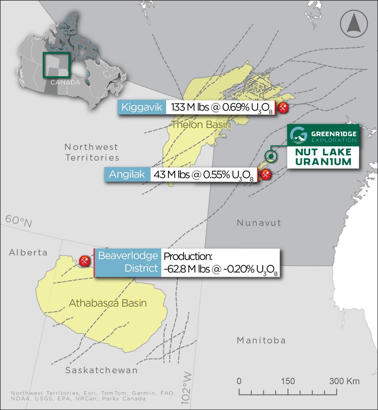
Figure 2- Map showing location of
Regional Geology at the Nut
Regionally, the Project lies along the eastern edge of the northeasterly trending wedge of Paleohelikian or
Archean gneisses are generally granitic to granodioritic in composition, with thin inter-layered bands of paragneiss or amphibolite. Syenites within the area are predominantly red, aphanitic, microsyenite, with some hornblende syenite locally. Microsyenite dikes intrude all other rock types along a northerly trend, exhibiting varying degrees of brecciation, especially near fault zones. These rocks contain variable amounts of magnetite, chlorite, disseminated hematite, and pyrite, with accessory zircon noted. The microsyenites are the most radioactive rocks in the area, containing an average of 100 ppm U, with uranium believed to be bound up in refractory minerals.
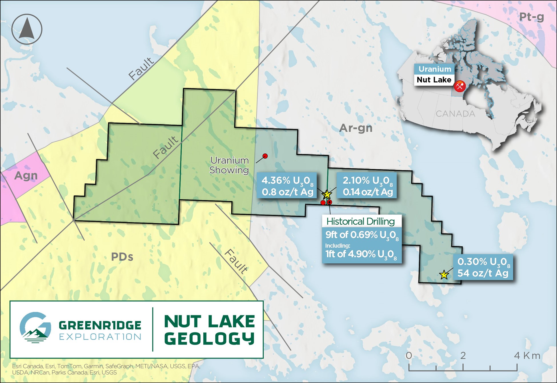
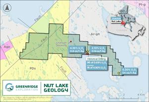
Figure 3 – Localized Nut Lake Property Geology Map. Source GSC Open File 4236. Abbreviations: PDs – Proterozoic Dubawnt Sediments; Agn / Ar-gn – Archean granitic rocks; Pt-g – Undivided Granites
About The Nut
The Project is located approximately 55km north of the Angulak Uranium Deposit² or 180Km southwest of
In 1979,
The Project hosts high grade vein hosted grab samples of up to 4.36% U3O8, 53.16 oz/t Ag, 1.15% Pb and 7.0% Ni.¹
During the 1979 field season, geological mapping at a scale of 1:1,000 was completed on a major portion of the Project. This was concurrent with prospecting on, and in the immediate area of the Project. Results from prospecting were the discovery of two (41 m wide) syenite dikes and a frost heaved area of felsic gneiss with up to 3,000 cps on fracture surfaces. Two significant Uranium bearing showings were discovered, the “Lake Showing” and the “Heartbreak Showing”. The most noteworthy was the Heartbreak showing which revealed 3.0” and 3.5” samples across a fracture that assayed 2.11% U3O8 and 4.36% U3O8 respectively. The results were followed up with a radon gal survey, a VLF-EM survey and an overburden sampling program. The radon survey results showed that the response is irregular with several good highs and the VLF-EM survey showed a series of northwesterly trending anomalies. It was concluded that further drilling of the
The Project and surrounding proximal area have seen approximately 805ft of
The combination of historically defined anomalies and modern exploration techniques provide prime ingredients for the potential of discovering a high-grade uranium system within the Project area. The Nut
National Instrument 43-101 Disclosure
References
1 Source: 1978 Assessment report (number 81075) by
2 Source: Reported by ValOre Metals Corp. in a Technical Report entitled “Technical Report and Resource Update For The Angilak Property,
3 Source: Jefferson, C.W., Pehrsson, S.J., Tschirhart, V., Peterson, T.D., Chorlton, L.B.,
4 Source: Areva Resources, NIRB File No. 09MN003,. (
5 Source:
About
On Behalf of the Board of Directors
Chief Executive Officer, Director
Telephone: +1 (778) 897-3388
Email: info@greenridge-exploration.com
Disclaimer for Forward-Looking Information
This news release contains certain forward-looking statements within the meaning of applicable securities laws. All statements that are not historical facts, including without limitation, statements regarding future estimates, plans, programs, forecasts, projections, objectives, assumptions, expectations or beliefs of future performance, including statements regarding the project acquisition bringing a low-risk opportunity, the Company, building a strong battery metals portfolio with low-risk opportunities that positively impact the Company and its shareholders and the Company providing an initial work plan are "forward-looking statements". Forward-looking statements in this news release include, but are not limited to, statements with respect to the Project and its mineralization potential; the Company’s objectives, goals, or future plans with respect to the Project; further exploration work on the Project in the future. These forward-looking statements reflect the expectations or beliefs of management of the Company based on information currently available to it. Forward-looking statements are subject to a number of risks and uncertainties, including those detailed from time to time in filings made by the Company with securities regulatory authorities, which may cause actual outcomes to differ materially from those discussed in the forward-looking statements. These factors should be considered carefully, and readers are cautioned not to place undue reliance on such forward-looking statements. The forward-looking statements and information contained in this news release are made as of the date hereof and the Company undertakes no obligation to update publicly or revise any forward-looking statements or information, whether because of new information, future events or otherwise, unless so required by applicable securities laws.
The Canadian Securities Exchange (CSE) does not accept responsibility for the adequacy or accuracy of this release.
Photos accompanying this announcement are available at:
https://www.globenewswire.com/NewsRoom/AttachmentNg/f238508a-80e9-4d6d-95c6-cb5a8d8fa65a
https://www.globenewswire.com/NewsRoom/AttachmentNg/28b0b119-6232-4110-a556-5f4fb8bf8775
https://www.globenewswire.com/NewsRoom/AttachmentNg/74e1d484-2e25-471d-afd5-4c48ad7de1cd

![]()
Figure 1 –
Nut Lake Property Regional Map
Figure 2-
Map showing location of Thelon Basin with respect to Athabasca Basin and the Beaverlodge Uranium district.
Figure 3 –
Localized Nut Lake Property Geology Map. Source GSC Open File 4236. Abbreviations: PDs – Proterozoic Dubawnt Sediments; Agn / Ar-gn – Archean granitic rocks; Pt-g – Undivided Granites
2024 GlobeNewswire, Inc., source