At the
21ENRC-03: 2m (1.6m true width) at 9.7 g/t Au from 52 meters down hole.
On M37/632 12 holes for 726 metres were drilled to test an anomalous structure identified from a drone magnetic survey. Sample assay results from this drilling has yielded one encouraging result which was in hole 21SDRC12 and intersected 4 metres at 0.45 g/t Au from 24 to 28 metres down hole.
A drone magnetic survey was flown over 4 blocks over the South Darlot licenses on 20m flight lines and a 20m flying height for all blocks with a section over the
A trial Deep Ground Penetrating Radar (DGPR) survey was conducted by Ultramag Geophysics over the
Red 5 Joint Venture
The original Joint Venture was formed in 2011 with a predecessor of Red 5 Limited, who on
CIO maintains it is entitled to an interest of at least 70%. This is disputed by Red 5 Limited.
Red 5 Limited and CIO are in advanced negotiations to resolve this matter, which resolution will only be binding upon the execution of a definitive binding agreement. We anticipate that the matter will be resolved in the near term.
British King
Under the terms of Tenement Acquisition Agreement dated
The registration of unencumbered title of that 51% interest is being delayed by Silverstream SE22, who provided funding to
SOUTH DARLOT GOLD PROJECT (
The Company’s
The British King Mine which is National Instrument 43-101 – Standards of Disclosure for Mineral Projects (“NI43-101”) compliant.The British King Mine is 5km southwest of Red 5 Limited’sDarlot Mine .The British King Mine is currently in care and maintenance.- A number of tenements which are subject to a joint venture with subsidiaries of Red 5 Limited (“Red 5”), details of which are set out below.
Figure 1a is available at https://www.globenewswire.com/NewsRoom/AttachmentNg/95df9007-9b42-4cf4-b21b-19a0799b107f
Figure 1b is available at https://www.globenewswire.com/NewsRoom/AttachmentNg/522f4300-de47-4678-b6f1-73c4387e2544
RED 5
The tenements set out in the table below (“Red 5 JV Tenements”) are the subject of a joint venture between the Company and subsidiaries of Red 5 Limited (“Red 5 JV”) and are situated southwest of Red 5’s Darlot gold mine and are contiguous with CIO’s current holdings in the area. The Red 5 JV Tenements are detailed below.
Table 1: List of South Darlot tenements
| Project | Tenement | Status | Area (ha) |
| Barrick JV | M37/421 | Granted | 381 |
| Barrick JV | M37/552 | Granted | 200 |
| Barrick JV | M37/631 | Granted | 776 |
| Barrick JV | M37/632 | Granted | 595 |
| Barrick JV | M37/709 | Granted | 98 |
| Barrick JV | M37/1045 | Granted | 90 |
Endeavour Prospect – RC Drilling
The
A total of five holes were drilled at the
The four shallow holes intersected a narrow 1 to 2 m wide quartz vein but failed to record any significant mineralsiation and it must now be concluded there is a depletion zone in the highly weathered upper horizon of this mineralised system.
Figure 2 is available at https://www.globenewswire.com/NewsRoom/AttachmentNg/545aca6a-7af4-4d51-8844-9b2db9f3c031
The fifth hole 21ENRC-03 targeted the quartz lode west of the known position of the lode and intersected 2 m @ 9.7 g/t Au from 50 metres down hole (true width of 1.6 metres). Figure 2 to 4 shows a plan, cross section and long section of the
Figure 3 is available at https://www.globenewswire.com/NewsRoom/AttachmentNg/f79b0153-f1e9-458c-bb67-bfe60506e5c4
Figure 4 is available at https://www.globenewswire.com/NewsRoom/AttachmentNg/aa6baa2c-f9d4-4658-bc03-ae15fb9d59c6
Figure 5 is available at https://www.globenewswire.com/NewsRoom/AttachmentNg/98a90200-8502-49b6-9c30-1e67dd05e7d0
Table 2: List of holes drilled in
| Hole_ID | Northing (mN) | Easting (mE) | Elevation (mRL) | Dip | Azimuth | Hole Depth | From | To | Interval | True Width | Au_ppm |
| 21ENRC01 | 6905845.67 | 328113.12 | 445.73 | -60 | 30 | 24 | 15 | 16 | 1 | 0.8 | 0.47 |
| 21ENRC02 | 6905837.35 | 328107.94 | 445.75 | -60 | 30 | 36 | NSI | ||||
| 21ENRC03 | 6905811.83 | 328092.20 | 445.82 | -60 | 30 | 60 | 52 | 54 | 2 | 1.6 | 9.39 |
| 21ENRC04 | 6905847.90 | 328102.11 | 445.89 | -60 | 30 | 30 | 19 | 20 | 1 | 0.8 | 0.31 |
| 21ENRC05 | 6905838.27 | 328096.17 | 445.94 | -60 | 30 | 42 | NSI | ||||
| 21SDRC01 | 6905821 | 328922 | 450 | -60 | 0 | 60 | NSI | ||||
| 21SDRC02 | 6905846 | 328922 | 450 | -60 | 0 | 60 | NSI | ||||
| 21SDRC03 | 6905871 | 328922 | 450 | -60 | 0 | 60 | NSI | ||||
| 21SDRC04 | 6905896 | 328921 | 450 | -60 | 0 | 60 | NSI | ||||
| 21SDRC05 | 6905823 | 328862 | 450 | -60 | 0 | 60 | NSI | ||||
| 21SDRC06 | 6905844 | 328865 | 450 | -60 | 0 | 60 | NSI | ||||
| 21SDRC07 | 6905869 | 328864 | 450 | -60 | 0 | 60 | NSI | ||||
| 21SDRC08 | 6905894 | 328865 | 450 | -60 | 0 | 60 | NSI | ||||
| 21SDRC09 | 6905819 | 328803 | 450 | -60 | 0 | 60 | NSI | ||||
| 21SDRC10 | 6905845 | 328800 | 450 | -60 | 0 | 60 | NSI | ||||
| 21SDRC11 | 6905877 | 328802 | 450 | -60 | 0 | 60 | NSI | ||||
| 21SDRC12 | 6905902 | 328803 | 450 | -60 | 0 | 60 | 24 | 28 | 4 | 3.2 | 0.45 |
M37/632 – RC Drilling
A structural target generated from the recent drone magnetics survey was drilled in
Figure 6 is available at https://www.globenewswire.com/NewsRoom/AttachmentNg/2324788c-f051-4199-984f-07482ad19afe
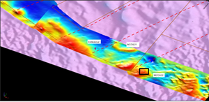
A low level, high-resolution rotary wing, drone-based magnetic survey of the South Darlot licenses on 20m flight lines and a 10m flying height covering an area of 6.6 km2 was flown over four areas in
Figure 7 is available at https://www.globenewswire.com/NewsRoom/AttachmentNg/3b9581a6-36b7-4e42-892d-54a4affa69a4
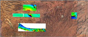
A trial Deep Ground Penetrating Radar (DGPR) survey was conducted by Ultramag Geophysics over the
Results from the survey are still being analysed; however, the initial findings are proving difficult to correlate to the known spatial position of the
Figure 8 is available at https://www.globenewswire.com/NewsRoom/AttachmentNg/5e9ee7ff-36c1-4996-a067-4e44e482d210
QUALIFIED PERSON
Mr
On behalf of the Board of Directors
“Brett Hodgins”
____________________________
For further information, please contact:
www.centralironorelimited.com
Investor and Media Inquiries:
Direct: +61 2 9397 7555
Email:info@centralironore.com
Neither the
THIS NEWS RELEASE IS NOT FOR DISTRIBUTION TO
Cautionary Note Regarding Forward-Looking Statements
This news release contains forward-looking information within the meaning of Canadian securities laws. Although the Company believes that such information is reasonable, it can give no assurance that such expectations will prove to be correct. Forward-looking information is typically identified by words such as: believe, expect, anticipate, intend, estimate, postulate and similar expressions, or are those, which, by their nature, refer to future events. The Company cautions investors that any forward-looking information provided by the Company is not a guarantee of future results or performance, and that actual results may differ materially from those in forward looking information as a result of various factors, including, but not limited to, the state of the financial markets for the Company’s equity securities, the state of the market for iron ore or other minerals that may be produced generally, recent market volatility; variations in the nature, quality and quantity of any mineral deposits that may be located, the Company's ability to obtain any necessary permits, consents or authorizations required for its activities, to raise the necessary capital or to be fully able to implement its business strategies and other risks associated with the exploration and development of mineral properties. The reader is referred to the Company's disclosure documents for a more complete discussion of such risk factors and their potential effects, copies of which may be accessed through the Company’s page on SEDAR at www.sedar.com.

![]()
Figure 1a
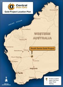
Locality map of the South Darlot project
Figure 1b
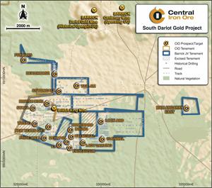
Locality map of the South Darlot project
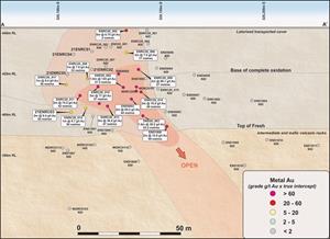
Figure 2
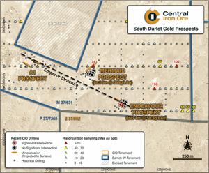
Plan of the Endeavour prospect on the Emperor Fault
Figure 3
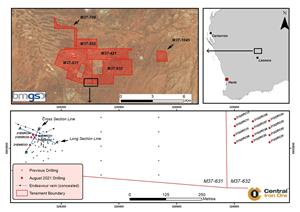
Plan of tenements and collar locations of recent drilling
Figure 4
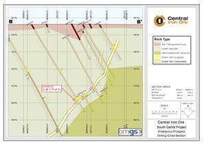
Cross section of the Endeavour showing hole 21ENRC-03
Figure 5
Long section of the Endeavour mineralised system showing 21ENRC-03
Figure 6
Plan view showing area drilled on M37/632
Figure 7
Drone magnetics surveying undertaken on the South Darlot tenements
Figure 8
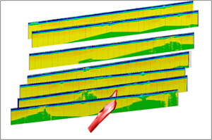
Lines of the DGPR survey in relation to the Endeavour lode (red) (looking west)
2021 GlobeNewswire, Inc., source
