Assays have been received for two additional drill holes that were not included in the recently announced NI 43-101 compliant mineral resource estimate (Please see Emerita’s news release dated
According to
Drill Hole LR146:
The Upper Lens was intersected at 580.9 m down the hole. It encountered 13.0 meters grading 0.2% Copper; 3.6% Lead; 13.1% Zinc; 1.35 g/t Gold and 120.9 g/t Silver; including 6.0 meters grading 0.3% Copper; 4.8% Lead; 15.9% Zinc; 2.32 g/t Gold and 181.5 g/t Silver. The Lower Lens was intersected at 593.9 meters down the hole. It comprised 22.9 meters grading 0.6% Copper; 2.0% Lead; 4.8% Zinc; 0.58 g/t Gold and 79.2 g/t Silver; including 3.9 meters grading 0.3% Copper; 6.1% Lead; 9.1% Zinc; 2.36 g/t Gold and 247.8 g/t Silver.
Drill Hole LR147:
The Upper Lens was intersected at 649.3 m down the hole. It encountered 16.5 meters grading 0.4% Copper; 0.1% Lead; 0.2% Zinc; 0.17 g/t Gold and 22.1 g/t Silver, including 2.0 meters grading 0.4 % Copper; 0.1 % Lead; 0.4 % Zinc; 0.22 g/t Gold and 106.5 g/t Silver. The Lower Lens was intersected at 665.75 m down the hole. It comprised 17.2 meters grading 0.4% Copper; 2.0% Lead; 9.8% Zinc; 0.64 g/t Gold and 89.3 g/t Silver; including 7.0 meters grading 0.5% Copper; 2.9% Lead; 16.5% Zinc; 0.83 g/t Gold and 57.0 g/t Silver.
The current drilling program is focused on testing the extension of La Romanera deposit at depth. Drill holes LR152 and LR153 are in progress. Drill holes LR148, LR150 and LR151 are completed with assays pending and have intersected significant massive sulphide intervals including; 40.0 m (24.0 m for the Upper Lens; 16.0 m for the Lower Lens), 4.3 m and 40.9 m (27.8 m for the Upper Lens; 13.1m for the Lower Lens) of massive sulphides, respectively; increasing the potential for additional resources expansion.
A down-the-hole transient electromagnetic (“TEM”) survey was completed in drillhole LR151, showing a conductor anomaly which continues for another 100 m at depth. The downhole TEM survey is being used by the exploration team to target the depth extension of La Romanera deposit.
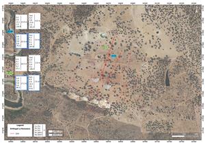
Figure 1: Diamond drilling plan map
View Figure 1 here: https://www.globenewswire.com/NewsRoom/AttachmentNg/062d6db0-4a8f-4138-b20b-8e366248a59b
Figure 2: Longitudinal section of the Lower Lens, La Romanera showing grade contours. Note the thick, high-grade trend of the deposit at depth where the extension drilling is focused. These areas are thicker and higher grade than the average resource grade which will provide an important contribution to a future resource estimate update.
View Figure 2 here: https://www.globenewswire.com/NewsRoom/AttachmentNg/0008b42a-49c7-4a7f-98bc-728d39015784
Figure 3: Longitudinal section of the Upper Lens, La Romanera showing grade contours. Note the thick, high grade trend at depth along the east side of the lens where the extension drilling is focused.
View Figure 3 here: https://www.globenewswire.com/NewsRoom/AttachmentNg/d625b583-948d-4d69-9169-c9ac68d8b6f4
*ZnEq % formula used for Figure 2 and 3: ZnEq % = [(Zn grade * Zn recovery * Zn price) + (Pb grade * Pb recovery * Pb price) + (Cu grade * Cu recovery * Cu price) + (Ag grade * Ag recovery * Ag price) + (Au grade * Au recovery * Au price)] / (Zn recovery * Zn price)
Table 1: Diamond Drilling Data
| DDH | Easting | Northing | Elevation | azimuth | dip | depth (m) | FROM | TO | Width (m) | Cu_% | Pb_% | Zn_% | Au_g/t | Ag_g/t | |
| LR146 | 646802 | 4172735 | 150 | 212 | -62 | 645.5 | 580.9 | 593.9 | 13.0 | 0.2 | 3.6 | 13.1 | 1.35 | 120.9 | UL |
| incl. | 585.9 | 591.9 | 6.0 | 0.3 | 4.8 | 15.9 | 2.32 | 181.5 | UL | ||||||
| LR146 | 593.9 | 616.8 | 22.9 | 0.6 | 2.0 | 4.8 | 0.58 | 79.2 | LL | ||||||
| incl. | 611.9 | 615.8 | 3.9 | 0.3 | 6.1 | 9.1 | 2.36 | 247.8 | LL | ||||||
| LR147 | 646751 | 4172871 | 154 | 198 | -56 | 701.3 | 649.3 | 665.8 | 16.5 | 0.4 | 0.1 | 0.2 | 0.17 | 22.1 | UL |
| incl. | 659.0 | 661.0 | 2.0 | 0.4 | 0.1 | 0.4 | 0.22 | 106.5 | UL | ||||||
| LR147 | 665.8 | 682.9 | 17.2 | 0.4 | 2.0 | 9.8 | 0.64 | 89.3 | LL | ||||||
| incl. | 674.0 | 681.0 | 7.0 | 0.5 | 2.9 | 16.5 | 0.83 | 57.0 | LL |
Next Steps
The Company has recently strengthened its treasury with successful financings generating gross proceeds of
- Continue to expand La Romanera Deposit at IBW. The Company presently has six (6) diamond drills operating on the Project.
- Complete the initial drilling on the historical
El Cura deposit which is situated approximately midway between La Infanta and La Romanera of the IBW property. This program has commenced. - Complete metallurgical studies on La Romanera and La Infanta. This program has commenced, and the Company has contracted metallurgical support from SRK to work as part of the owners team and selected
Wardell Armstrong LLP of theUK , who are highly experienced with Iberian Pyrite Belt deposits, to do the actual laboratory testing for the metallurgy. - Complete initial conceptual mine planning to a level appropriate to support site selection for future infrastructure as well as conversion of Exploration Licenses to Exploitation Licenses at IBW. Grupo IPH, a Spanish mining engineering firm based in
Huelva that contracts for mines in the region is being contracted to complete this work. - Complete the initial exploration drilling campaign at the Nuevo Tintillo project. Drilling will commence after the summer season when heat related operating restrictions have been lifted.
Baseline Studies Completed
- BIOGEOS, Estudios Ambientales SL
- Diseño de Soluciones Medioambientales (DSM)
- Laboratorios MICROAL SL
The Baseline Studies were initiated in
The Environmental Baseline Study lasted one year and consisted of the following technical analyses:
- Diagnosis of the natural environment and landscape.
- Analytical investigation of soils and water (surface and subsurface).
- Hydrological and hydrogeological study (water balance).
The purpose of the work carried out has served to:
- Establish a Mining-Environmental management process necessary to establish a zoning of areas, delimiting exclusion zones and admission zones for future activities and facilities linked to the future mining exploitation.
- To update the official environmental information offered by the
Environmental Administration .
Quality Assurance/Quality Control
Drilling at La Romanera is HQ size and core is placed into core trays at the drill site and transported directly from the site to Emerita’s coreshack (15Km) from La Romanera and (8Km) from La Infanta. Once the cores are received at Emerita's coreshack they are photographed and geotechnical logging is performed. Geological, mineralogical and structural logging follows and mineralized zones are identified. The samples are marked every 1m or less, and respecting lithological contacts, with most of the samples 1.0m long. The zone immediately above and below the mineralized zones are also sampled. Core samples are sawed in half and half of the core is returned to the core tray for future reference. Once the core samples are cut, bagged and tagged, they are shipped to the ALS laboratory in
10% of the analyzed samples correspond to control samples (fine blanks, coarse blanks, high, medium and low grade standards). In addition, 10% of pulps are reanalyzed at a second independent certified laboratory (AGQ Lab Sevilla). When the analysis is completed, the certificates are received from the laboratory and the QA/QC protocol identifies any deviation or anomaly in the results and the entire batch is reassayed in such case. Once the data is approved by the QA/QC protocol assays are entered digitally directly into the database.
Qualified Person
The scientific and technical information in this news release has been reviewed and approved by Mr.
About
Emerita is a natural resource company engaged in the acquisition, exploration and development of mineral properties in
For further information, contact:
+34 (628) 1754 66 (
+1 778 990 9433 (
info@emeritaresources.com
Cautionary Note Regarding Forward-looking Information
This press release contains “forward-looking information” within the meaning of applicable Canadian securities legislation. Forward-looking information includes, without limitation, the mineralization of the
NEITHER TSX VENTURE EXCHANGE NOR ITS REGULATION SERVICES PROVIDER (AS THAT TERM IS DEFINED IN THE POLICIES OF THE


Figure 1
Diamond drilling plan map
Figure 2
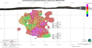
Longitudinal section of the Lower Lens, La Romanera showing grade contours. Note the thick, high-grade trend of the deposit at depth where the extension drilling is focused. These areas are thicker and higher grade than the average resource grade which will provide an important contribution to a future resource estimate update.
Figure 3

Longitudinal section of the Upper Lens, La Romanera showing grade contours. Note the thick, high grade trend at depth along the east side of the lens where the extension drilling is focused.
2023 GlobeNewswire, Inc., source
